If you are thinking about relocating to Frisco, one of the first things you’ll notice is the energy. This city is a booming suburb located about 25 miles north of Downtown Dallas, and it has grown incredibly fast over the last two decades. But with that growth comes a very specific reality regarding transportation: Frisco was built for the car.
Unlike some older urban centers, Frisco is designed with the assumption that residents own vehicles. While there are pockets of walkability and some exciting future tech on the horizon, getting around here requires understanding the highway systems, the toll costs, and the commute patterns. Here is the local scoop on how to navigate the city, from the “spine” of the Tollway to the best way to get to the airport.
Driving in Frisco: The Primary Mode of Transport
Because Frisco is relatively new in terms of major development, it benefits from a very logical, master-planned grid system. If you look at a map, you’ll see major thoroughfares running north-south (like Preston Road and Coit Road) and east-west (like Main Street and Eldorado Parkway) roughly every mile.
This grid makes navigation fairly forgiving; if you miss a turn, you can usually just take the next major road and loop back. However, the secret is out about living in Frisco TX, and that popularity means traffic volume has increased. You should expect congestion during school drop-off/pick-up times and traditional rush hours, especially near popular retail hubs.
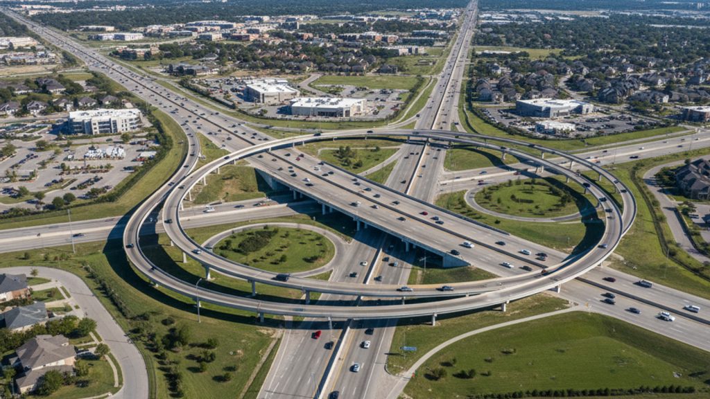
Navigating the Toll Roads: DNT vs. SRT
To survive the commute here, you need to get comfortable with toll roads. They are the arteries that keep the city moving. There are two massive highways you will use almost daily, both managed by the North Texas Tollway Authority (NTTA).
- Dallas North Tollway (DNT): Think of this as the “spine” of Frisco. It runs North-South right through the center of West Frisco. This is your primary route for commuting to Plano, Addison, or Downtown Dallas.
- Sam Rayburn Tollway (SH 121): This runs along the southern border of Frisco. It is your primary East-West connector. You’ll take the SRT to go east toward McKinney or west to reach DFW Airport.
- US 380: This highway forms the northern border of Frisco (University Dr). It is not a toll road, but it is currently known for heavy construction and traffic as development pushes north.
- Preston Road (SH 289): If you want to avoid tolls, Preston is the main North-South alternative. However, it is dense with traffic lights, shopping centers, and restaurants, so it is significantly slower than the DNT.
A Local’s Tip on the TollTag: If you drive in Frisco, you absolutely need a TollTag. There are no cash booths on these roads. If you drive without a tag, the cameras will snap your license plate, and you will receive a “ZipCash” bill in the mail. ZipCash rates are roughly 50% higher than the TollTag rate. You can pick up a sticker at local grocery stores or order one online—it saves you a fortune in the long run.
Public Transportation Options in Frisco
This is the part of the conversation where I have to manage expectations. If you are moving from a city with a robust metro or subway system, Frisco will be a culture shock.
The DART Void Frisco is not a member of DART (Dallas Area Rapid Transit). Years ago, the city voted to use its sales tax revenue for the Economic Development Corporation (EDC) rather than paying into the regional transit system. This strategy helped build the multi-billion dollar mile and attract corporate HQs, but it means there are no DART trains or buses running within Frisco city limits.
DCTA Demand Response You might hear about the Denton County Transportation Authority (DCTA) operating here. It is important to clarify that this is a “Demand Response” service. It is not a bus you can just hop on. It is a curb-to-curb service specifically designed for seniors (65+), individuals with disabilities, or specific medical trips. It generally requires an application and eligibility approval.
Ride-Sharing is the Standard For the general population, if you don’t have a car, you are likely using Uber or Lyft. These services are the de facto public transit for a night out or a trip to the airport. They are plentiful and reliable, but they can get pricey if used for a daily commute.
Estimated Commute Times to Major Hubs
One of the biggest questions we get from people pros and cons of living in Frisco is, “How long will I be in the car?” It depends heavily on where you work. Rush hour on the DNT generally hits hardest from 7:00–9:00 AM and 4:30–6:30 PM.
Here is a realistic look at commute times:
- Frisco to Downtown Dallas: Expect 45–60+ minutes during rush hour via the DNT. Without traffic, it’s closer to 35 minutes, but “no traffic” is rare during the work week.
- Frisco to Legacy West (Plano): This is a massive employment hub (Toyota, Liberty Mutual, JPMorgan Chase) just south of the border. It’s a breezy 10–15 minute drive.
- Frisco to DFW International Airport: Thanks to the Sam Rayburn Tollway (SRT), this is a very consistent 25–35 minute drive. It is a fast, direct shot west.
- Frisco to Dallas Love Field: This airport is closer to downtown, so you’ll take the DNT south. Plan for 35–45 minutes.
Walkability and Biking: Can You Ditch the Car?
In general, Frisco has a low “walkability” score. Most residential neighborhoods are strictly residential, meaning you can’t easily walk to a grocery store or coffee shop from your front door.
However, the city has done a great job creating “park-once-and-walk” districts. The Star (where the Dallas Cowboys practice) and Frisco Square (near City Hall and the library) are designed to be pedestrian-friendly. You can park your car and spend the whole evening walking between restaurants, shops, and entertainment venues.
If you are looking for recreation rather than transportation, Frisco has an incredible hike and bike trail system. The city is working on the “Six Cities Trail” connectivity, and local paths like the Cottonwood Creek Trail and Taychas Trail are fantastic for cycling and running. While some residents use these to bike to work if they live close to their office, they are primarily used for lifestyle and fitness.
The Future of Frisco Transport: AVs and Vertiports
Frisco prides itself on being a “Smart City” sandbox, often testing new technology before the rest of the country. You might remember the Drive.ai pilot program a few years back, where bright orange self-driving vans were ferrying people around office parks. While that specific pilot has ended, the infrastructure for Autonomous Vehicles (AVs) is still a priority for city planners.
Looking further ahead, Frisco Station has partnered with companies like Uber Elevate and Joby Aviation to plan for “Vertiports.” The goal is to eventually offer urban air mobility—essentially flying taxis—to whisk commuters from Frisco to DFW Airport in minutes. While you can’t book a flight just yet, it’s a sign of how the city is trying to innovate its way out of traditional traffic congestion.
Frequently Asked Questions About Getting Around Frisco
Does DART run in Frisco?
No, DART (Dallas Area Rapid Transit) does not operate trains or bus lines in Frisco. The train line ends in Plano to the south. To use the train, you would need to drive to the Parker Road Station in Plano.
Can I get around Frisco without a car?
It is very difficult to live here without a personal vehicle. While you can use ride-share apps like Uber and Lyft for occasional trips, the city’s layout and lack of general public transit make a car essential for daily errands and commuting.
How much is an Uber from DFW Airport to Frisco?
The cost varies based on demand and the specific drop-off location, but you should typically budget between $45 and $60. During peak surge times or holidays, this rate can be higher.
Does Frisco have public transportation?
Frisco does not have a general public bus system. The DCTA operates a limited “Demand Response” service, but this is primarily for seniors and individuals with disabilities and requires eligibility approval.