When looking at homes for sale in Plano, understanding the local transportation network is just as important as the property itself. This major suburb sits strategically within the Dallas-Fort Worth metroplex, offering a mix of sprawling highway infrastructure and expanding public transit. Getting around Plano TX efficiently requires knowing which toll roads to take and how to leverage the local rail system.
Whether you commute daily to Downtown Dallas or travel frequently out of DFW Airport, your daily route will heavily influence where you choose to live. The city has recently seen massive upgrades to its transit systems, making navigation more efficient than ever for new residents in 2026. Buyers who map out their commute before purchasing often find they can save hours of weekly travel time.
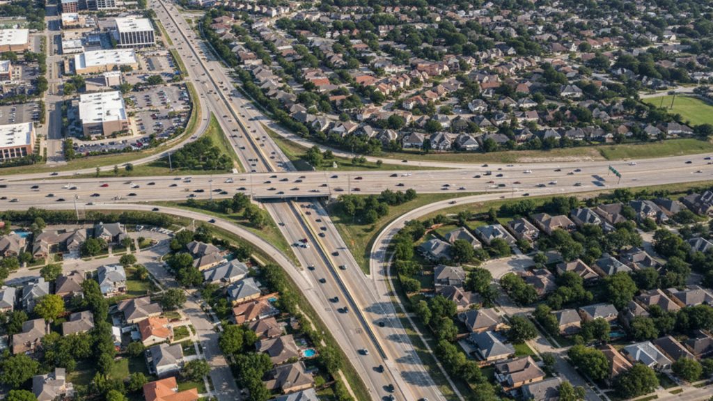
Driving and Commuting in Plano
Most residents in North Texas rely on a personal vehicle for their daily commute. Plano is anchored by three primary routes that dictate traffic flow across the broader region. Understanding how these highways intersect is critical for estimating your daily travel times before committing to a neighborhood.
The Dallas North Tollway borders the western edge of the city, providing a straight shot southward into the Dallas core. On the southern border, the President George Bush Turnpike connects drivers east and west across the wider metroplex. Meanwhile, US Highway 75 serves the eastern neighborhoods, acting as a major non-tolled artery for north-south travel.
Because the North Texas Tollway Authority manages the major expressways here, acquiring a TollTag is practically mandatory for daily drivers. Commuting to Downtown Dallas typically takes 40 to 60 minutes during peak rush hour, though that drops closer to 30 minutes in light traffic. The TollTag system automatically deducts fares as you drive, eliminating the need to stop at toll booths entirely.
If your job requires frequent air travel, reaching Dallas Fort Worth International Airport by car takes roughly 30 to 45 minutes. Selecting a home near one of these major highway access points can easily streamline your weekly routine. Traffic conditions fluctuate heavily, so mapping your drive during actual rush hour is always recommended before making a final housing decision.
Dallas Area Rapid Transit (DART) Services
For buyers who prefer to skip the highway traffic, the Dallas Area Rapid Transit system provides a robust alternative. Plano serves as a major northern hub for this sprawling regional transit network. Utilizing public transit here is a highly viable option for those working in central Dallas or near the airport.
The city is currently served by three primary rail connections that cater to different commuting needs:
- The Red Line terminates at the Parker Road station, offering a direct rail connection to Downtown Dallas in about 45 to 50 minutes.
- The Orange Line extends into the city during peak commuting hours, providing additional capacity for riders heading south.
- The Silver Line commuter rail, which opened in late 2025, gives residents a direct, train-to-terminal transit link straight into DFW Airport Terminal B.
Beyond the trains, local bus routes and the GoLink on-demand shuttle service bridge the gap between residential streets and main transit hubs. GoLink operates in specific zones, allowing riders to request a shuttle pickup right from their smartphone. This multimodal approach ensures that even neighborhoods located further from the rail stations remain seamlessly connected.
Riders can manage all of their trips using the GoPass app, which simplifies the entire public transit experience. The application offers real-time tracking, contactless payment, and fare capping to keep daily commuting costs predictable. Fare capping ensures that once you spend a certain amount in a day or month, all subsequent rides are completely free.
Navigating Plano Without a Car
While the broader Dallas-Fort Worth metroplex is famous for its car-centric layout, certain pockets of Plano offer excellent walkability. Buyers seeking a lifestyle where they can walk to dining and amenities should focus their search on specific centralized zones. These areas command a premium but deliver a highly convenient, pedestrian-focused environment that is rare in the suburbs.
Historic Downtown Plano features dense, walkable streets lined with local restaurants, retail spaces, and immediate access to the DART rail. On the western side of the city, the Legacy Business Park and the surrounding Shops at Legacy provide a master-planned, mixed-use setting. In these districts, residential units sit just steps from major employment centers and entertainment venues.
For cyclists, the city maintains an extensive network of shared-use paths and continuous sidewalks that connect neighborhoods to local parks. The newly completed Cotton Belt Regional Trail, which parallels the Silver Line, has drastically improved non-motorized travel across the northern suburbs. This paved path provides a dedicated route for both commuting cyclists and weekend recreational riders.
Living entirely car-free in Plano is challenging unless you reside directly within one of these specific mixed-use districts. However, relying on a multimodal approach – combining a bicycle with the DART train – is a highly practical way to navigate the area. Most residents find that keeping a car for weekend errands while using transit for the workday offers the best balance.
Ridesharing and Regional Connectivity
When public transit does not align with your schedule and you prefer not to drive, ridesharing easily fills the gaps. Uber, Lyft, and other ridesharing company services operate heavily throughout the city at all hours. Wait times are generally very short, even in the more sprawling residential neighborhoods located on the city edges.
A typical rideshare trip from Plano into central Dallas usually costs between $30 and $60, depending on surge pricing and your exact drop-off location. This makes it an easy option for evening events or quick trips across town without worrying about parking. For longer temporary needs, numerous car rental agencies are stationed throughout the city to accommodate residents and visitors.
The city’s centralized location also makes it incredibly easy to reach neighboring communities without a complex transit plan. The seamless blend of transit and highway networks provides quick access to major employment hubs in Richardson, Texas. You can also easily connect to broader regional transit systems heading out toward Fort Worth, Texas.
For those requiring specialized transport, the city and DART offer comprehensive Paratransit services. These programs ensure that riders with disabilities have reliable, accessible transportation options throughout the week. Eligible residents can schedule specialized pickups to reach medical appointments, grocery stores, and community centers with complete ease.
Why Buyers and Sellers Choose Bale Real Estate Group
Buying or selling in Plano requires more than just timing the market. The Bale Real Estate Group helps clients understand pricing, competition, and how to position a home so it stands out immediately. For sellers, that includes strategic pricing, professional staging, targeted marketing, Zillow Showcase exposure, and our Certified Pre-Owned Home Listing Program. The goal is simple: maximize exposure and drive stronger offers.
Frequently Asked Questions About Getting Around Plano
Does Plano have public transportation?
Yes, the city is heavily integrated into the Dallas Area Rapid Transit network. Residents utilize light rail, commuter rail, traditional local bus routes, and on-demand GoLink shuttles for daily travel. This robust infrastructure makes it one of the most transit-connected suburbs in North Texas.
Which DART line goes to Plano?
The city is primarily served by the Red Line, which connects the Parker Road station directly to Downtown Dallas. The Orange Line provides additional peak-hour service, and the newly opened Silver Line offers commuter rail access straight to DFW Airport.
Is Plano, Texas a walkable city?
While the overall suburb requires a vehicle for most daily errands, specific districts offer high walkability. Historic Downtown and the Legacy Business Park feature dense, pedestrian-friendly layouts with immediate access to dining and transit. Outside of these zones, continuous sidewalk networks and trails support recreational walking rather than practical commuting.